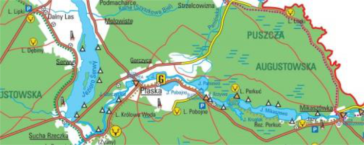
Gmina Płaska – historical facts
Gmina Płaska exists as a separate administrative unit since 1973. Płaska, the village which was made from the old loggers’ hamlet, is its commune office. There are two versions of the village’s name’s origin. The first one assumes that the name descends from the old name of the nearby river which is a part of the canal system – Sucha Rzeczka vel Serwianka vel Paniówka. Second version is connected to the first pioneer of the village who was named Płaska. Gmina Płaska contains a lot of scenic cities – the beauty of their wild nature harmonizes perfectly with the architecture of the national heritage. In this magical place the time has been slow-paced so you could experience echo of the yesteryear.
Mikaszówka
Mikaszówka village, whose name is connected with the nearby lake noted in the XV century as the Mukuschewo Parva, deserves special attention. It stayed untouched by humanity until the XVII century. In 1661 – 1668 Konstancja Wodyński Butlerowa, widow of the army commander, created Mikaszewska Ore. First mineworkers there were Skrodzy and Domuradowie and it was one of the most profitable ores in Augustów Primeval Forest. In the latter part of the XVII century property right conflict between royal clerks and Camaldolese has started. Sadly, the beginning of the XVIII century was also not gracious for the pioneers – 15 of them have died because of the plague. After the Polish Republic’s demise, Mikaszewska Ore became the clerks’ property. On 12th July 1863, Polish insurrectionists fought with the Russian army here. According to the Geographical Dictionary of the Kingdom of Poland from 1885, the old ore became the Mikaszówka village. This village located near the Hańcza-Czarna river in the Augustów County, contained 19 houses and 128 villagers.
In 1875 bishop Wierzbowski proposed to the government with the idea of creating a parish in Mikaszówka but the first wooden single-nave church with the Black Madonna of Częstochowa in its altar, was not created until 32 years later. In 1921 the village contained 33 houses and 200 villagers and one year later the first one classed elementary school was created and contained 35 students.
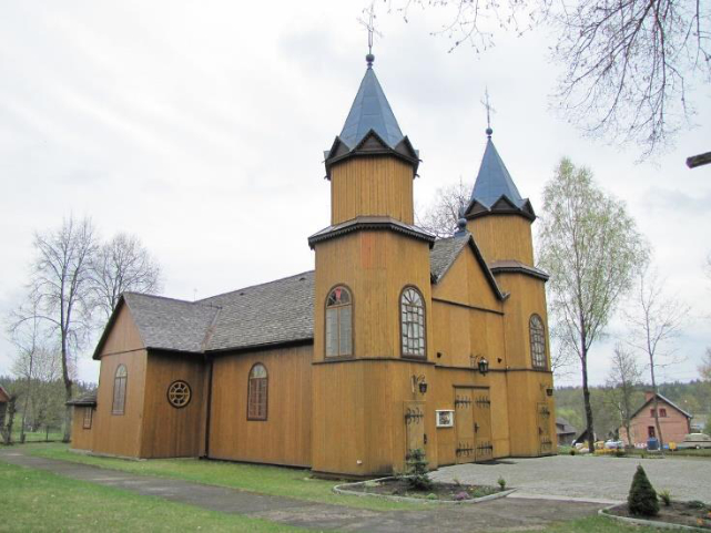
source: https://pl.wikipedia.org/wiki/Mikasz%C3%B3wka#/media/Plik:PL_MIKASZ%C3%93WKA_WOODEN_CHURCH.JPG
Serwy
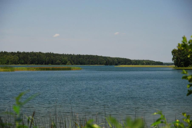
The name of this city descends from the nearby lake’s name. Serwy Lake was granted in the prince Witold’s days to the grodzieński parson. The lake was owned sequentially by the king Kazimierz Jagiellończyk and prince Aleksander in 1494. All the islands on the lake and the nearby forests were owned by the king. However, this area was not colonized yet. At the end of XV century Żabiczów family obtained king’s permission to create and use wild beehives in the nowadays Serwy’s area. In 1506 the king granted land on the right side of the lake to the Chreptowicz family. Since two families had permission to use these forests, it quickly initiated a dispute between them. Later, Chreptowicz family tried to convert forests of the Ostrów Dubrowy and started tree grubbing to build their court. On 30th July 1608 the king stated that the Chreptowicz family had rights only to the east, not to the property of that area. The family had to resign from trying to take control over the Serwieńska Forest.
There are notes from that time span proving the existence of some cabins by the lake which were owned by the local pitch burners, tal workers and loggers. In the latter part of the XVII century Camaldolese from Wigry preordained deforestation of some area nearby Serwy lake to sow it. Marcin Głowczyk from Tobolowo, their subject made it happen in 1690. That was the beginning of the village Serwa.
Almost one century later in Serwy, the first tavern was created and in 1786 total of residents was 44 people. The city expanded satisfactorily. In 1827 the village contained 74 residents and the only owner of the land became the government of the Kingdom of Poland by buying some land off of Jan Augustowski and Jan Kamieński’s heirs. After the January Uprising the process of enfranchisement of the king’s land has started. At the end of XIX century the village was located in the Szczebra Olszanka Gmina and the Studzienicz parish. At that time the number of houses there was 23 and the number of residents – 33. However, in 1921 there were 24 houses occupied by 126 people. What is more, the map from 1927 suggests the existence of some forest inspectorate near the village.
Gorczyca
Gorczyca is one of the oldest cities in the Płaska Gmina. In 1668 king Jan Kazimierz granted Stanisław Gorczyca a privilege to create a new mine on its lands. That’s how the Gorczyca Ore, which gave rise to colonization of the present-day Gorczyca village, was made. Even though the one with the privilege of benefiting from the ore was Jan Gorczyca, the organizer of the whole venture was Konstancja Wodyński Butlerowa, leaseholder of the Perstuńska forest which contained that area. The ore was located in the west side of the village, nowadays called: “Stara Ruda”.
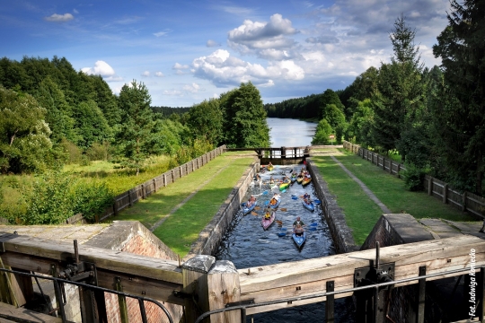
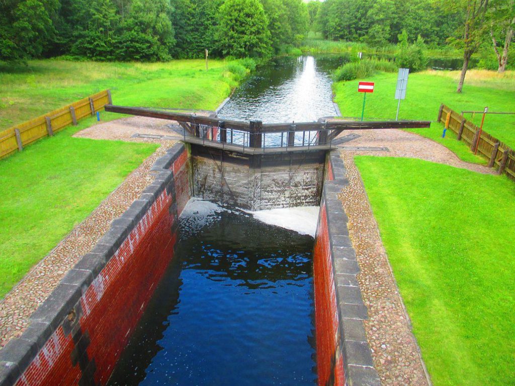
At the end of the XVIII century authorities of the Grodzieńska Economy took up a task of ordering forest villages by craving the exact location of forestlands, fields and meadows. Even though the forest meadows were taken from the pioneers, residents were able to keep the meadows of Płaska and the queen Wanda’s. According to the documents of Grodzieńska Economy, at the end of the XVIII century the tavern traditionally owned by Jews was created. Nowadays the area of the contemporary tavern is called Jordyga or Jews Street. According to data from 1792 there were 5 landowners in Gorczyca Ore – overall, 8 farmers and 43 residents. At the end of the XIX century, miners stopped ore smelting and left the hamlet or became farmers. At the time when the Augustów Canal was made, one of the locks was created. During the general census in 1921 it was noted that in the Gorczyca village there were 37 houses and it was occupied by 185 residents.


#/media/Plik:Jezioro_serwy_podlaskie_02.jpg)